🎉 Up to 70% Off Selected ItemsShop Sale

Imray 2510 - North Brittany Chart Pack
Imray 2510 - North Brittany Chart Pack
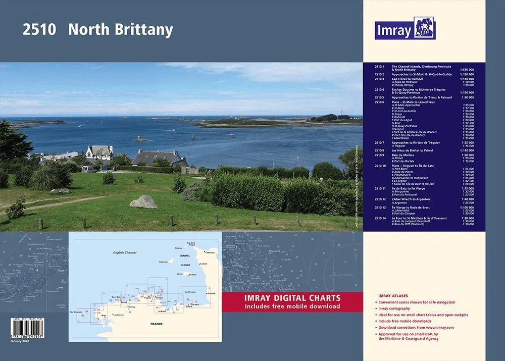
The award winning Imray navigational charts allow for easy chart plotting in any conditions.
This edition of the 2510 paper chart pack is printed and corrected to January 2020.
- Sheet size A2 59 x 42 cm - wirobound in plastic wallet
- Convenient scales chosen for safe navigation
- Imray cartography
- Ideal for use on small chart tables and open cockpits
- Shows tidal stream diagrams
- Approved for use on small craft by the MCA
- Latest chart corrections available on the Imray website
The pack of charts in the atlas include:
- The Channel Islands, Cherbourg Peninsula & North Brittany
- Approaches to St-Malo & St-Cast-le-Guildo
- Cap Frehel to Paimpol
- Roches Douvres to Riviere de Treguier & St-Quay-Portrieux
- Approaches to Riviere de Trieux & Paimpol
- Plans - St-Malo to Lezardrieux
- Approaches to Riviere de Treguier
- Les Heux de Brehat to Primel
- Baie de Morlaix
- Plans - Treguier to Ile de Batz
- Ile de Batz to Ile Vierge
- L'Aber Wrac'h to Argenton
- Ile Vierge to Rade de Brest
- Le Four to St Mathieu & Ile d'Oussant
$28.30
Original: $80.85
-65%Imray 2510 - North Brittany Chart Pack—
$80.85
$28.30More Images

Imray 2510 - North Brittany Chart Pack
Imray 2510 - North Brittany Chart Pack
The award winning Imray navigational charts allow for easy chart plotting in any conditions.
This edition of the 2510 paper chart pack is printed and corrected to January 2020.
- Sheet size A2 59 x 42 cm - wirobound in plastic wallet
- Convenient scales chosen for safe navigation
- Imray cartography
- Ideal for use on small chart tables and open cockpits
- Shows tidal stream diagrams
- Approved for use on small craft by the MCA
- Latest chart corrections available on the Imray website
The pack of charts in the atlas include:
- The Channel Islands, Cherbourg Peninsula & North Brittany
- Approaches to St-Malo & St-Cast-le-Guildo
- Cap Frehel to Paimpol
- Roches Douvres to Riviere de Treguier & St-Quay-Portrieux
- Approaches to Riviere de Trieux & Paimpol
- Plans - St-Malo to Lezardrieux
- Approaches to Riviere de Treguier
- Les Heux de Brehat to Primel
- Baie de Morlaix
- Plans - Treguier to Ile de Batz
- Ile de Batz to Ile Vierge
- L'Aber Wrac'h to Argenton
- Ile Vierge to Rade de Brest
- Le Four to St Mathieu & Ile d'Oussant
Product Information
Product Information
Shipping & Returns
Shipping & Returns
Description
Imray 2510 - North Brittany Chart Pack
The award winning Imray navigational charts allow for easy chart plotting in any conditions.
This edition of the 2510 paper chart pack is printed and corrected to January 2020.
- Sheet size A2 59 x 42 cm - wirobound in plastic wallet
- Convenient scales chosen for safe navigation
- Imray cartography
- Ideal for use on small chart tables and open cockpits
- Shows tidal stream diagrams
- Approved for use on small craft by the MCA
- Latest chart corrections available on the Imray website
The pack of charts in the atlas include:
- The Channel Islands, Cherbourg Peninsula & North Brittany
- Approaches to St-Malo & St-Cast-le-Guildo
- Cap Frehel to Paimpol
- Roches Douvres to Riviere de Treguier & St-Quay-Portrieux
- Approaches to Riviere de Trieux & Paimpol
- Plans - St-Malo to Lezardrieux
- Approaches to Riviere de Treguier
- Les Heux de Brehat to Primel
- Baie de Morlaix
- Plans - Treguier to Ile de Batz
- Ile de Batz to Ile Vierge
- L'Aber Wrac'h to Argenton
- Ile Vierge to Rade de Brest
- Le Four to St Mathieu & Ile d'Oussant